Showing posts with label rivers. Show all posts

Thursday, 7 November 2019

Running the lost river Peck


Secret Rivers, a recent exhibition at the Museum of Docklands, highlighted London’s lost and neglected waterways. As the city spread in the 19th century rivers and streams were increasingly covered up and diverted underground through pipes and sewers. Still for the most part they continue some kind of subterranean existence and we may even find some ghostly traces remaining above ground.

One such 'lost river' is the Peck, which apart from one small section has largely disappeared from view in its South London home. A couple of weeks ago I set out to run its course.

View from One Tree Hill
I started from One Tree Hill at Honor Oak close to the supposed source of the river, always a bracing run up to the summit from Brenchley Gardens. From the top there are great views across London. I paused too to remember the time I played three-sided football there 20 years ago

. There's no sign of the river here or on its route flowing down to Peckham Rye, although running down Kelvington Road/Cheltenham Road towards the Rye you do pass another hidden body of water - the covered Honor Oak Reservoir with its improbable Aquarius Golf Club course on top.

Peckham Rye park is the only place where a section of the Peck can still be seen.
Along with many other runners I have lapped this park many times during Peckham parkrun. The course crosses the narrow stream and its rivulets five times so each parkrunner crosses 15 times every Saturday morning.


The area of the park through which the stream flows was first laid out in the late 19th century with its current course there being the result of human landscaping. It is sometimes little more than a trickle, but at least here the water can be seen and appreciated.


One part of the park is known as the Sexby Gardens, named after horticulturist and first Superintendent of London County Council Parks Department, Lt-Colonel J.J. Sexby who oversaw the development of many London parks. His fascinating 1905 book ‘The municipal parks, gardens, and open spaces of London; their history and associations’ includes a description of the Peckham Rye water features:  'In a secluded hollow delightfully shaded with trees a lake has been made. It has an island in the centre and is fed by a small watercourse running though the grounds, which has been formed into a number of pools by artificial dams. This rivulet has its source in a fountain springing out of the rockwork, and thence meanders through the park, receiving some life when babbling over some miniature waterfalls before its entrance to the lake' (you can read/download the whole book for free at archive.org)

Illustration from Sexby's book

The river now disappears underground with its course following the western edge of the park (Dulwich side) towards Peckham. Greenwood's 1830 Map of London  shows what seems to be a pond fed by the river on the north end of the Common, the triangle now cut off by East Dulwich Road. This was also the location of Peckham Lido which was open from 1923 to 1987 - plans have been put forward to rebuild it, we can only hope.


Peckham Lido

 The map shows the river carrying on down Peckham Rye, past the White Horse (a pub of the same name still stands on the same spot) and then more or less  following the line of what is now Copeland Road, with a footpath alonside it. In the 1830s it seems to have filled a pool in what is marked on the map as a brick field site - this may have been a result of quarrying rather than a natural feature.

1830 map


After that the river is believed to have crossed Queens Road and headed towards the Old Kent Road crossing it at a point somewhere north of the the Ilderton Road junction - I ran down Consort Road, Kings Grove and alongside Brimmington Park to Old Kent Road then crossed over and ran down Ormside Road before joining Ilderton Road. Somewhere in the vicinity of South Bermondsey Station the Peck joined the Earls Sluice, another now buried stream which still flows on to the Thames - but today as part of an underground sewer. I will return to the Earls Sluice another day.


Peckham Lights - from a series of contour maps of the Peck and its environs by artist Loraine Rutt

Here's my River Peck running route - full details on mapmyrun - just under 7k  though I actually ran 12k getting to and from the route. It's an approximation of the course of the river, as there are fences, railways and buildings in the way 


For other people's takes on the route see: London's Lost Rivers, Londonist,  Peckham Society, Diamond Geezer


Sunday, 27 August 2017

Running in Lisbon

Lisbon is a great city for a holiday - good food, drink, largely unspoilt old buildings and streets in the centre, great art galleries and museums, and beaches within easy reach by cheap public transport. But what's it like to run in?

Well like all hot places in the summer, it's best to run early in the morning. I found that by 7:30 am in August it was already getting uncomfortably hot to run,  but in any case in a busy tourist destination you need to be out early to avoid the crowds and traffic. As in most cities, early on the only people on the streets are runners and clubbers from the night before.

The other factor is that, like Rome, Lisbon is a city built on seven hills. As I will explain, there are some flatter runs possible, but not too many.
'Build sofas not walls' - sand sculpture

Lisbon sits on the River Tagus where it runs into the Atlantic so the most straightforward flat route is to run along the river. I started out on my first day at the riverfront in front of Praça do Comércio (a main square in the centre) and just turned right and headed west. You can stay on the riverbank for large parts of the run, in places there are docks and other fenced off places that push you away from the river, but it's easy enough to follow paths parallel to the river until you can rejoin it. If you're worried about getting lost, just wait until another runner comes along and follow them - there's a steady stream in the morning.

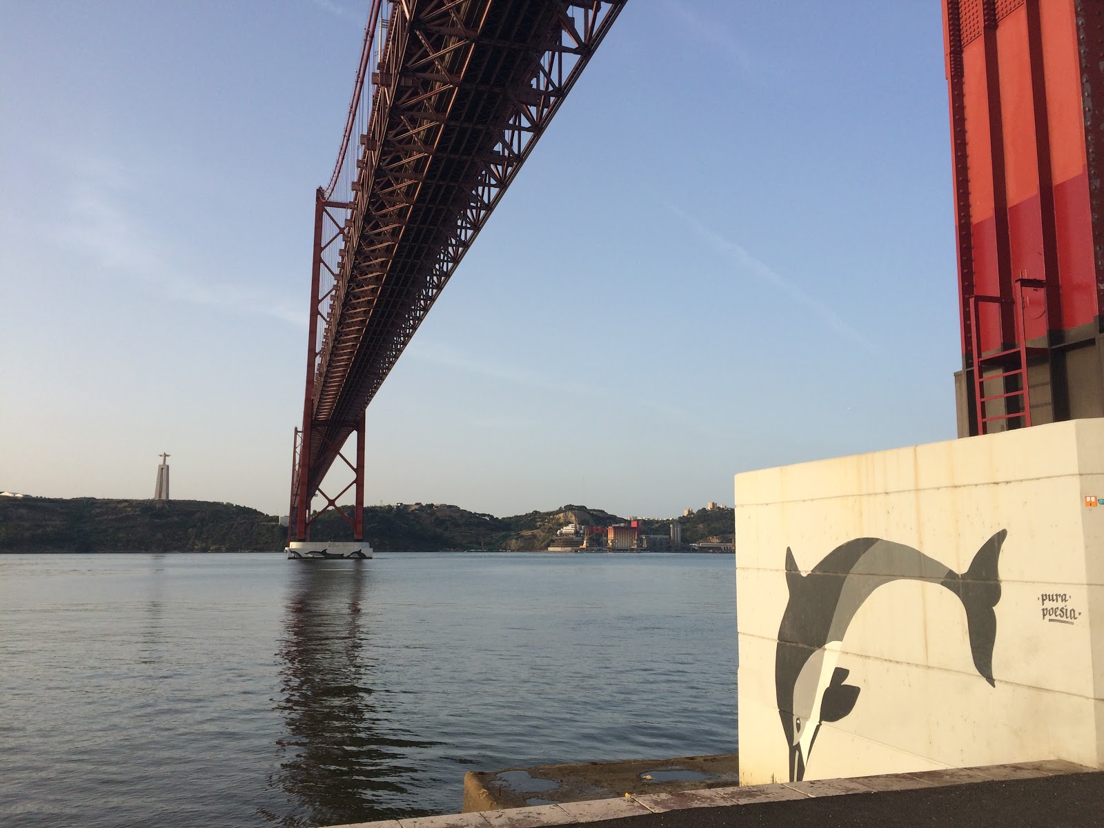
I ran for about three miles to the Ponte 25 de Abril (25 April bridge), a Golden Gate style suspension bridge which crosses the river  - it takes its current name from the revolt of 25 April 1974 that ended more than 40 years of fascist-style dictatorship. And no you can't run across it, it's strictly for vehicles except during the annual Lisbon Half Marathon where it forms part of the course.

Other runners take the train from Cais do Sodre train station to Belem a bit further along the river (where many of the museums/galleries are) from where you can run out beyond the city and along the coast out to the beaches to the west.


Not so flat, but not too much of an incline is the Avenida da Liberdade (Liberty Avenue), a tree lined and therefore relatively shady boulevard heading north west from Rossio square. This is a good run of over 1 km before you reach a park, Parque Eduardo VII. As with many of Lisbon's streets you are running on tiles or cobbles which are not always as even as they appear - so lift those knees up!

Avenida da Liberdade


In the park on the east side (the right side if you are coming up from city centre) is the Carlos Lopes pavillion, a  1920s building renamed in honour of the Portuguese winner of the 1984 Los Angeles Olympics Marathon in 2:09:21. Apparently there is a small permanent exhibition inside including his running shoes from 1984, but unfortunately  the building was closed when I visited. 


Carlos Lopes Pavillion


Parque Eduardo VII

Getting to the highest point in Lisbon up by the castle does mean some serious step climbing - once again best earlier not just because of the heat but because heading up through the old town Alfama district means negotiating narrow streets which can get quite crowded, not to mention dodging trams. Easy to get lost but if you come up from the river front as long as you are going uphill you are going in approximately the right direction. Don't stress about losing your GPS signal amidst the alleyways, that's goes with the territory.

Above and below - climbing up through Alfama district


The Baixa district consists of a grid of parallel streets that is similar to London's West End, with lots of globally familiar high street shops. These are a godsend to runners before they get busy, fairly flat, some pedestrianised and with the buildings casting some shade. One morning I just ran up and down the grid.


The arch at the bottom of Rua Augusta in Baixa district
As I mentioned before you can get the train - for a mere 5 Euros or so return - out the to the various beaches to the west of Lisbon. In most cases the train stops right next to the beach. We went to Estoril a couple of times, where I had a run along the front followed by swim in the sea.


Estoril

Another great thing about Lisbon is that having burnt off some calories running you can treat yourself to some of the finest pastries. Of course you can get a Pastel de nata (Portuguese custard tart) in many British cafes now. But can you buy them from places where you can choose just how burnt you want the top?!


Conclusion - go to Lisbon, and pack your running shoes.


Some of my Lisbon runs on Strava -


Friday, 25 March 2016

In search of the River Clyde

So you turn up somewhere new, and the first thing you do is look on a map to find a good run. And hey it looks like one of the great rivers of the world is really close so that's sorted. But then you try and find it and it's not quite so simple...

Last week I was in Glasgow staying for the first time at the Glasgow East/Black Bear Premier Inn, close to the Daldowie crematorium where I was attending a family funeral. On Google Maps the mighty River Clyde was shown just a short distance away - central to Glasgow's history as the home of its shipbuilding industry and on whose banks my father once worked as an apprentice at the Alexander Stephens shipyard. My idea of a perfect place to run, but the roads had other ideas. A lot of hotels like this are built for obvious reasons close to major roads, in this case handily located at the junction of the M73 and M74 motorways, not to mention the busy A721. And getting to the river from the hotel meant negotiating these pedestrian-tormenting highways.


My first effort, involving running across Motorway slip roads, got me as far as the North Calder Water, a smaller river  that flows into the Clyde at Daldowie. Every route through to the Clyde itself seemed to be blocked by a motorway, a fence or a quarry.

The North Calder Water at Daldowie

The next day I did find a way through, for the sake of any runners staying there in future, here's a short description of the route: come down from hotel to the main road (A721) and turn left. Follow main road as it passes under the M73, go past a small roundabout, and then take the first road to the right - Blantyre Farm Road. Keep on this road as it passes over the M74 and then sweeps round to the right to a bridge over the Clyde.


The River Clyde from Blantyre Farm Road bridge, looking East.
On the far side of the bridge over the river you can clamber down a steep bank on the right. Take care - if you lose your footing you may crash into a barbed wire fence at the bottom, though there is a stile to get you over the fence.


Then you can run right next to the river along an uneven but runnable sandy path. How far you can go depends on how high the river is- I was able to keep going for about half a mile, so the whole run from hotel to end of path along Clyde and back was about 3.7 miles (see run on strava). If I'd had more time to explore I might have found a way through to run further along the river. It's a great stretch of the river here, as it heads from the countryside into the city.

River Clyde


Bishops Loch, Easterhouse


I was in Glasgow for the funeral of my Auntie, Jessie Campbell Mitchell (1933-2016). She died recently in the Glasgow Royal Infirmary, and I was glad that I got to visit her there a few weeks ago. Like my dad, she was born on Islay, and as the Minister mentioned in the service (at St. Andrews Church, Bailleston) she didn't speak English until she started school as my grandparents spoke Gaelic at home. Moving to Glasgow, she worked at the United Biscuits factory and then later at Wills cigarette factory - I remember once going to some kind of works sports day for children at one of these places, not sure if I did any running though, think it was sack races and the like!

On family holidays we would invariably stay with her in Glasgow on our way to Islay. She lived in Easterhouse, and later in Bailleston. The former I remember as being quite grey, but on returning last week I realized just how close it is to the countryside (and some of the greyer tenement blocks have now been demolished). There are several small lochs nearby which we would sometimes walk round, but I didn't remember them being so near to what was one of the city's biggest housing estates.

Me and my son went for a wander last week at Bishop Loch, overlooked by the old Gartloch Hospital buildings and surrounded by marshland.  With a bit of running I did find a pathway through the woods down to the loch side.

Bishop Loch, Easterhouse
Marshland at Bishop Loch

Auntie Jessie with me and my wedding

Sunday, 7 February 2016

Running London: all 12 South London Boroughs Completed!


I got given the 'Runners's Guide to London' by Hayden Shearman for Christmas, with its promise of  '300 pages, over 120 runs, 100s of photos, 100-odd maps, trails, parks, canals, pathways, athletics tracks, indoor tracks, races, clubs, history, interviews with local legends ... everything RUNNING and LONDON is in this book'.

It's a well-designed book, with full colour photos and maps on every page. But for me the test for a London book is whether its coverage extends to all parts the city, not just the usual tourist areas covered by various types of guide books. In particular, the South East London area where I live is often overlooked in 'London' books other than a brief mention of Greenwich. I'm glad to say that the 'Runners Guide to London' scores very postively on this score, with a decent South East section matching those for all other parts of London, each of which includes a mixture of recommended running hot spots (such as parks, hillls and woods) with longer routes. For South East London for instance the latter includes The Green Chain and The Waterlink Way from Sydenham to Deptford Creek. There is a also a section on the capital's greatest route of all - The Thames Path.  I  recommend this book whether you are a runner living in London, or you're just visiting and want to explore the city on foot - get a copy here.

Run Every Borough Challenge

One idea in the book is the 'Run Every Borough Challenge'. London is divided into 33 local government areas - 32 boroughs plus the City of London. The challenge is simply to 'Find somewhere beautiful  to run in every borough in London', in the process maybe exploring parts of the city that even the born and bred Londoner might not be familiar with.

I quickly worked out that I had run in 16 of the 33 boroughs, including 10 of 12 located south of the River Thames. So today I decided to complete the southern part of the challenge by running in the London Boroughs of Sutton and Kingston.

In the former I went for a four mile run along the River Wandle trail, starting out in Beddington Park.

A bridge over the River Wandle in Beddington Park


In the park, the river feeds a large pond and is also diverted into a narrow stream with some picturesque bridges.

Beddington Park
 I followed the river up as far as the wildfowl-rich Waddon ponds and then headed back.

Waddon Ponds

Afterwards I headed on to Malden in Kingston, where I ran  for a bit along another London river, the Hogsmill. The run was a little disappointing, mainly because what looked on the map like a good route along the river was actually interrupted by the impossible to cross A3 road. Eventually I found a subway but I spent much of the run on suburban streets trying to find a way to the river, and the section I ran had a muddy/slippery path.  But I did my four miles on the streets of Kingston borough, so that's another one on the list. 


The Hogsmill River in Elmbridge Meadows (behind Elmbridge Avenue).
So here's my progress in the Run Every Borough Challenge so far (runs completed in each borough in brackets):

South of the River-

Lambeth  (Streatham Common cross country, Clapham Common 10k, Brockwell Park)
Southwark  (Southwark parkrun, Peckham Rye parkrun, Dulwich parkrun, Burgess parkrun)
Bromley  (Crystal Palace parkrun, start of Assembly League race in Beckenham, Kent Vets XC at Sparrows Den)
Lewisham  (Hilly Fields parkrun, Ladywell track etc)
Wandsworth (Battersea Park Assembly League race)
Greenwich  (Greenwich Peninsula Assembly League race, start of London Marathon)
Croydon (Croydon Half, Farthing Downs cross country)
Richmond (Richmond Park 10k, Surrey League cross country, Bushy parkrun)
Bexley (Sidcup 10 mile)
Merton (Mitcham Common cross country, Wimbledon Common cross country)
Kingston (Hogsmill river)
Sutton (Wandle river run)

North of the River -

City of London  (City of London Mile, London Marathon)
City of Westminster (London Marathon finish, Regents Park 10k)
Tower Hamlets  (Victoria Park Assembly League race)
Hackney (Hackney Marshes 5k)
Newham (ran to Olympic Stadium during canal runs)

Still to do (all North of the River):

Kensington and Chelsea
Hammersmith and Fulham
Islington
Brent
Ealing
Hounslow
Havering
Barking and Dagenham
Redbridge
Waltham Forest
Haringey
Enfield
Barnet
Harrow
Hillingdon

Clearly going to have to get out to the far east and west across the river. Luckily there's a good google map showing all the boundaries, not to mention some good destinations in The Runners Guide to London.

Sunday, 15 November 2015

River Runscapes

There's an interesting newish group on facebook called 'Our Runscapes' where people post photographs of where they run as part of 'an exploration of running and the landscape - where we choose to train and run'. 

Lately some of my favourite runscapes have involved meetings with remarkable rivers. When you turn up in a town that has a river running through it, you know there's a strong chance of a great run - after all there will probably be a flattish path alongside and not too many road crossings to worry about. But there's also something about the motion of a river, the steady but powerful flow onwards that every runner aspires too. Here's a few photos taken out running this year.

River Severn in  Shrewsbury


Shrewsbury is surrounded by a loop of the River Severn, with a wide tree lined path along much of its town-side bank. The suspension bridge (above) is by the Quarry, the main park in the town centre where Shrewsbury parkrun takes place every Saturday.


Statue of Hercules by the River Severn in Shrewsbury


River Cam


Staying in Cambridge for a wedding in July, I went out for a ten mile run on a Sunday morning. The River Cam has the added inspiration of serious rowing clubs out on the water from early in the morning. I ran along the south bank from Jesus Green out to Stourbridge Common, on the way back coming across people getting ready for Race for Life, where thousands of pink-clad runners traced a similar route as part of their 10k raising funds for cancer research.

ponies by the River Cam


River Lym

In Lyme Regis over the summer we were lucky to be staying in a house right next to the River Lym, and there is some great running to be had along the river and out of town to the old mill and beyond


River Ravensbourne

The River Ravensbourne runs through much of my South East London heartland, including close to my club's track, so I always seem to be running along or near to it. I will do it justice in a post of its own another time, but here it is glimpsed through the trees in Ladywell.


<


River Lea

The River Lea rises in Luton, where I was born and grew up. Earlier in the year on separate days I ran both its first few miles and its last, to where it joins the River Thames in East London.


The River Lea in Luton (stretch by Birdsfoot Lane)


River Thames

 Which brings us to the great River Thames itself. I guess most London runners have spent a lot of time running along, over and even under it - the latter through the Greenwich foot tunnel. The photo below was taken at the end of a long run to where the River Lea flows into the Thames by Trinity Buoy Wharf. Across the river where the cable car lands is where I ran  in the Assembly League on the Greenwich peninsula. A few miles to the West the Embankment where I ran along the river on in the closing miles of the London Marathon.  Many other memories floating off downstream.