Showing posts with label Running London. Show all posts

Thursday, 7 November 2019

Running the lost river Peck


Secret Rivers, a recent exhibition at the Museum of Docklands, highlighted London’s lost and neglected waterways. As the city spread in the 19th century rivers and streams were increasingly covered up and diverted underground through pipes and sewers. Still for the most part they continue some kind of subterranean existence and we may even find some ghostly traces remaining above ground.

One such 'lost river' is the Peck, which apart from one small section has largely disappeared from view in its South London home. A couple of weeks ago I set out to run its course.

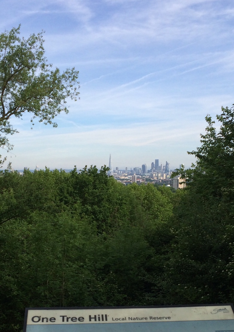
View from One Tree Hill
I started from One Tree Hill at Honor Oak close to the supposed source of the river, always a bracing run up to the summit from Brenchley Gardens. From the top there are great views across London. I paused too to remember the time I played three-sided football there 20 years ago

. There's no sign of the river here or on its route flowing down to Peckham Rye, although running down Kelvington Road/Cheltenham Road towards the Rye you do pass another hidden body of water - the covered Honor Oak Reservoir with its improbable Aquarius Golf Club course on top.

Peckham Rye park is the only place where a section of the Peck can still be seen.
Along with many other runners I have lapped this park many times during Peckham parkrun. The course crosses the narrow stream and its rivulets five times so each parkrunner crosses 15 times every Saturday morning.


The area of the park through which the stream flows was first laid out in the late 19th century with its current course there being the result of human landscaping. It is sometimes little more than a trickle, but at least here the water can be seen and appreciated.


One part of the park is known as the Sexby Gardens, named after horticulturist and first Superintendent of London County Council Parks Department, Lt-Colonel J.J. Sexby who oversaw the development of many London parks. His fascinating 1905 book ‘The municipal parks, gardens, and open spaces of London; their history and associations’ includes a description of the Peckham Rye water features:  'In a secluded hollow delightfully shaded with trees a lake has been made. It has an island in the centre and is fed by a small watercourse running though the grounds, which has been formed into a number of pools by artificial dams. This rivulet has its source in a fountain springing out of the rockwork, and thence meanders through the park, receiving some life when babbling over some miniature waterfalls before its entrance to the lake' (you can read/download the whole book for free at archive.org)

Illustration from Sexby's book

The river now disappears underground with its course following the western edge of the park (Dulwich side) towards Peckham. Greenwood's 1830 Map of London  shows what seems to be a pond fed by the river on the north end of the Common, the triangle now cut off by East Dulwich Road. This was also the location of Peckham Lido which was open from 1923 to 1987 - plans have been put forward to rebuild it, we can only hope.


Peckham Lido

 The map shows the river carrying on down Peckham Rye, past the White Horse (a pub of the same name still stands on the same spot) and then more or less  following the line of what is now Copeland Road, with a footpath alonside it. In the 1830s it seems to have filled a pool in what is marked on the map as a brick field site - this may have been a result of quarrying rather than a natural feature.

1830 map


After that the river is believed to have crossed Queens Road and headed towards the Old Kent Road crossing it at a point somewhere north of the the Ilderton Road junction - I ran down Consort Road, Kings Grove and alongside Brimmington Park to Old Kent Road then crossed over and ran down Ormside Road before joining Ilderton Road. Somewhere in the vicinity of South Bermondsey Station the Peck joined the Earls Sluice, another now buried stream which still flows on to the Thames - but today as part of an underground sewer. I will return to the Earls Sluice another day.


Peckham Lights - from a series of contour maps of the Peck and its environs by artist Loraine Rutt

Here's my River Peck running route - full details on mapmyrun - just under 7k  though I actually ran 12k getting to and from the route. It's an approximation of the course of the river, as there are fences, railways and buildings in the way 


For other people's takes on the route see: London's Lost Rivers, Londonist,  Peckham Society, Diamond Geezer


Friday, 30 March 2018

Running London: Wembley Stadium

I am continuing my effort to run in all 33 London boroughs (only 3 left to do) and today ticked off the London Borough of Brent with a run round one of the city's most iconic sporting venues - Wembley Stadium. OK I wasn't running around the pitch, but there's a good flat circuit around the outside of the Stadium that is perfect for laps of just under 1 km.


The current version of the Stadium only dates back to 2007 of course, replacing the 1920s Stadium that was demolished in 2003. But the location has nearly 100 years of sporting history, including athletics as the main venue for the 1948 Olympic Games. Obviously it is most associated with football, and most football fans will have their good and bad memories.

Me and Bobby Moore  - there's a Bobby 2 Bobby Wembley Strava segment
The high point for me was the April 1988 League Cup Final, when Luton beat Arsenal 3-2 - I can't believe that was thirty years ago next month. I can honestly say that was one of the happiest days of my life - the game had everything, Luton going ahead, then Arsenal scoring twice to take the lead, Luton keeper Andy Dibble saving a penaly and then another Luton goal before Brian Stein scored the winner in the last minute. It was pure joy in the crowd (amongst the Luton supporters anyway!), I remember me, my dad and my friend Paul just jumping around for ages. That feeling stayed with me for days afterwards, in fact I can still summon it up when I remember it. 


Low point was going to Wembley as a child with my dad in 1975 for the England/Scotland match. My dad bought a fold up wooden stool for me to stand on so that I could see the action from the terraces. Unfortunately as a Scotland supporter it wasn't a pretty sight - England won 5-1 (I could also  mention seeing Luton lose 4-1 to Reading in the 1988 Simod Cup Final but in my mind that has been recorded over by the victory over Arsenal a few weeks later).


Sunday, 4 June 2017

New Burgess parkrun route

Southwark's Burgess Park hosts one of my favourite parkruns, scene of my PB and recognised as being one of the flatter and faster courses in the London area. I've written about it here before, but recently there has been a change to the course. I went along and ran it yesterday, chasing my second sub-20 5k in three days after a good outing in the Assembly League race in Battersea Park on the preceding Thursday. I didn't make it, but can confirm this is still a good course if you are looking for a fast 5k time.
 
 
As before the course starts at the far west of the park near the Camberwell Road entrance, and heads off for a long straight before taking a turn and looping around the Burgess Park lake. The main change is that the old course used to go twice round the lake- nice and picturesque (what with its herons and all), but sometimes resulting in congestion as there would be a lot of lapping around the lake.  The new course only goes round the lake once before heading up to the far east of the park by the Trafalgar Avenue entrance.
 
runners on the home stretch with the Aylesbury Estate in the background
There is a slowing hairpin turn there,  but once negotiated it's a long straight run (I think about 1.2k) from one end of the park to the other. Mentally it's quite tough, as it does seem quite a stretch, but there is nothing to slow momentum other than going down then up through the underpass that takes the path under the road at Wells Way.
 
 
At the very end there is a sharp left turn towards the finish funnel on the grass, other than that it's tarmac all the way. The finishing line is actually within the funnel by the flag, so as the sign says make sure you 'run all the all way to the flag'. Friendly crowd and team as always, they have fresh fruit at the end for a donation.
 
 
 Kent AC's Gareth Anderson was first man home yesterday in 16:48,  Amy Cook first woman in 21:04, with a total of 286 finishers.


Sunday, 28 May 2017

Running London: Brockley and Nunhead Five Peaks (10k route)

Last summer's 'Lewisham 3 Peaks Challenge' was a successful charity walk linking three South East London hill tops with fine views across the capital - Hilly Fields, Blythe Hill Fields and One Tree Hill in Honor Oak. An excellent map  with lots of interesting historical detail has been produced, designed by Linda Durrant (Full Circle Design), to promote this as an ongoing walking route.


Detail of Brockley Three Peaks Walk, showing Ladywell Arena athletics track

 
I picked up a copy in the Hilly Fields café after parkrun there and thought I would give it a go as a run, but to mix it up a bit and increase the distance I added in a couple more hills - Telegraph Hill and the hill in Nunhead Cemetery historically known as Nunhead Hill.
 
It is a good run, just over 10k in total, with plenty of up and down hill stretches of course. Toughest part is the steep stairs to the top of One Tree Hill, but as with all the hills there is the reward of the view from the top. An added advantage is that for several sections of the run it is possible to run on grass.

View from Hilly Fields with Crystal Palace TV transmitter on the horizon
and Blythe Hill Fields also visible above the tree line

View from Blythe Hill Fields with Canary Wharf on the horizon
 

The Shard and the City of London visible from top of One Tree Hill

View from top of Nunhead Cemetery - St Pauls Cathedral is visible through the gap in the trees (though not very clear in this photo). The artists JMW Turner sketched St Pauls from near this spot

London skyline from Telegraph Hill upper park


Wednesday, 22 February 2017

Running London: South London Windmill Run

The few remaining windmills in the London area are a reminder of the capital's history of absorbing formerly separate rural villages into the expanding city's urban fabric. With a 17 mile long run target as part of my London marathon training I decided to set off last weekend on a windmill-themed run across South London, taking in Peckham, Brixton, Clapham and Wimbledon.

In Peckham, on the corner of Choumert and Bellenden roads, there is a 2014 mural featuring a windmill landscape. It does not, as I first thought, represent an image of Peckham past. In fact I have found no evidence of there ever having been a windmill in Peckham, though there were a number at different times in the Camberwell area. The local connection to this mural is rather more obscure - it was painted by Walter Kershaw as one of a number of works inspired by paintings in the Dulwich Picture Gallery collection.  The windmills are in fact reproduced from a John Constable painting at DPG, which is in itself a copy of 'Landscape with Windmills near Haarlem’ by Jacob Van Ruisdael (1650).


Heading on to Brixton we find a fine windmill at the end of Blenheim Gardens, off Brixton Hill. The Ashby Mill was built in 1816 and remained a working mill until 1935. It has been restored as a result of the efforts of the Friends of Windmill Gardens and others, and was officially reopened in 2011.


The windmill has its own mural nearby in Lyham Road. The lettering at the bottom reads ''The Windmill revamped by community love, will hold us together if push comes to shove'.


The nearby pub, The Windmill, is one of South London's great music venues. Have had some excellent nights there, folk sessions, punk gigs and alt country events. Particularly recall People's Republic of Disco club nights, seeing Art Brut when they were just breaking (Geoff Travis of Rough Trade was in the crowd, think he had just signed them or was about to), and Pine Valley Cosmonauts. 


On Clapham Common there is another landmark pub with the same name.


As the sign outside says, there has been a Windmill pub in that location since at least 1665. Clearly there must originally have been a windmill there too, but it doesn't seem to have lasted  too long as 'milling must have become less important, and beer selling more important'.


Running on to Wimbledon Common I passed near to the remains of another windmill on Wandsworth Common, but confess I didn't actually see it.

The mill on Wimbledon Common, at the end of Windmill Lane of course, is in good condition. It may not have its own pub, but it does have The Windmill tearooms next door.


A sign above the entrance to the windmill states that Baden-Powel wrote part of his book 'Scouting for Boys' (1908) in the mill house.


According to the information sign at the site, it was built by local carpenter Charles March in 1817 and remained open until 1864 when the Lord of the Manor, the fifth Earl Spencer proposed to enclose Wimbledon Common 'and build himself a new Manor House just south of the windmill'. Fortunately this scheme was successfully opposed by local residents, leading  to 'the Commons being protected by the Wimbledon and Putney Commons Act 1971'.

As a result of these endeavours, the common remains open for all and among the many sporting associations using it are the Wimbledon Windmilers running club - I saw a group of them meeting up at the Windmill for a run on Sunday. 

Only the week before (11 February 2017) several hundred of us ran over the Common in the final race of the 2016-17 Surrey League men's cross country competition - did I mention that my club, South London's finest Kent AC, won the competition for the 5th year in a row?!


Start of the Surrey League finale on Wimbledon Common, 11 February 2017

My windmill route, which included exploring other parts of Wimbledon on the way back, and getting lost in Tooting, is on Strava.


Other Running London posts:


Thursday, 9 February 2017

Running London: tracking the city's first railway journey

As somebody reminded me on twitter, yesterday was the anniversary of the birth of the London railways. On 8 February 1836, the first section of the London and Greenwich Railway was opened, with trains between Deptford and Spa Road in Bermondsey - the first passenger steam trains in the capital. Over the next few years the line was extended to reach London Bridge at one end and Greenwich at the other.

Today I decided to retrace that first train journey, running as near as I could the track from Deptford to Spa Road and indeed beyond to Druid Street then Tooley Street.


The railway not only transformed transport but the architecture of the city. To avoid the need for lots of level crossings, the railway was elevated above street level on a viaduct with hundreds of brick arches. 

Arches in Deptford

The site of the original Spa Road station is marked by a plaque commemorating 'London's first railway terminus, opened 1836'.


There is also a large photo on display of the old station.


The bridge where the railway crosses Spa Road is a grand structure supported on pillars.


As I ran alongside the railway I reflected on all the ever changing uses of these railway arches, home over the decades to countless stables, workshops, scrap metal yards, churches, gyms, boxing clubs, nightclubs, studios and in their latest incarnation offices like the Neal's Yard Dairy HQ on Druid Street.  I thought of great nights out in railway arches like the Cross club at Kings Cross, Shunt at London Bridge or various arches in 1990s Brixton.  It's been a similar picture in other cities, such as Glasgow, where of course one of the most iconic clubs until it closed in 2015 was The Arches. As urban property has become more valuable and tightly policed, railway arches in some areas are losing their cheap/marginal/semi-outlaw status, but the history of these places isn't played out yet.

Many of these arches have their own distinct stories, some glorious, some tragic. In the latter category, a plaque on Druid Street recalls the Druid Street Arch Bombing when on 25 October 1940 a Nazi bomb killed 77 people sheltering in a railway arch. 


site of the Druid arch bomb, October 1940
(I ran alongside the track for about 3 miles, for most of it close to the line though there were a couple of points where it's not possible to do so - see run details on strava)


Sunday, 5 February 2017

Running London: in praise of the Greenwich Foot Tunnel

The Greenwich Foot Tunnel is one of the most important routes for London runners on the East side of the city.  With no pedestrian friendly river crossings between it and Tower Bridge five miles upstream (I don't recommend running through the vehicle fumes of the Rotherhithe tunnel, though technically you could), the  370m tunnel connects the north and south banks of the Thames at a very useful point. 

Of course its entrance on the Greenwich side is an iconic running location in its own right, marking with the Cutty Sark ship Mile Seven of the London Marathon route. On Sunday mornings in particular in the lead up to the Spring Marathon season a seemingly never ending stream of runners pass through the tunnel during their long run training. For runners from South  London heading north, the tunnel gives access to parks and waterways of the Isle of Dogs and East London along which it is possible to run for miles with very little interruption from roads. For those heading north to south, the tunnel opens up the way to the hilly Greenwich Park and the green expanse of Blackheath, as well as to Thames-side routes around the Greenwich peninsula up to the 02/Dome and beyond.  


Last weekend for instance a group of us did a 14 mile run from Greenwich that included following the Regents Canal to Victoria Park, then the Hertford Union Canal up to the Olympic London Stadium and back. Yesterday my 16 mile route took me to Mile End, where I did the parkrun before heading back via Limehouse and Millwall Docks to the foot tunnel.


The tunnel was opened in 1902, and was originally intended to help dock workers from the South side get to work on the Isle of Dogs. It was commissioned by the London County Council, with former docker and later Labour MP Will Crooks having a key role as chair of the LCC's Bridges Committee. So runners can thank him and the workers who dug the tunnel through the chalk by hand.

For runners passing through today the main dilemma seems to be whether to use the lift or the stairs - 100 of them at the Greenwich end. Most seem to descend via the spiral staircase but get the lift back up.


(Running Past has written a bit more about the history and notes that  to mark the centenary of the tunnel in 2002, 100 people ran a Greenwich Foot Tunnel Centenary Marathon entirely inside the tunnel (58 laps). Hugh Jones, winner of the 1982 London Marathon, won the tunnel event in a time of 2.45.40).

Sunday, 7 February 2016

Running London: all 12 South London Boroughs Completed!


I got given the 'Runners's Guide to London' by Hayden Shearman for Christmas, with its promise of  '300 pages, over 120 runs, 100s of photos, 100-odd maps, trails, parks, canals, pathways, athletics tracks, indoor tracks, races, clubs, history, interviews with local legends ... everything RUNNING and LONDON is in this book'.

It's a well-designed book, with full colour photos and maps on every page. But for me the test for a London book is whether its coverage extends to all parts the city, not just the usual tourist areas covered by various types of guide books. In particular, the South East London area where I live is often overlooked in 'London' books other than a brief mention of Greenwich. I'm glad to say that the 'Runners Guide to London' scores very postively on this score, with a decent South East section matching those for all other parts of London, each of which includes a mixture of recommended running hot spots (such as parks, hillls and woods) with longer routes. For South East London for instance the latter includes The Green Chain and The Waterlink Way from Sydenham to Deptford Creek. There is a also a section on the capital's greatest route of all - The Thames Path.  I  recommend this book whether you are a runner living in London, or you're just visiting and want to explore the city on foot - get a copy here.

Run Every Borough Challenge

One idea in the book is the 'Run Every Borough Challenge'. London is divided into 33 local government areas - 32 boroughs plus the City of London. The challenge is simply to 'Find somewhere beautiful  to run in every borough in London', in the process maybe exploring parts of the city that even the born and bred Londoner might not be familiar with.

I quickly worked out that I had run in 16 of the 33 boroughs, including 10 of 12 located south of the River Thames. So today I decided to complete the southern part of the challenge by running in the London Boroughs of Sutton and Kingston.

In the former I went for a four mile run along the River Wandle trail, starting out in Beddington Park.

A bridge over the River Wandle in Beddington Park


In the park, the river feeds a large pond and is also diverted into a narrow stream with some picturesque bridges.

Beddington Park
 I followed the river up as far as the wildfowl-rich Waddon ponds and then headed back.

Waddon Ponds

Afterwards I headed on to Malden in Kingston, where I ran  for a bit along another London river, the Hogsmill. The run was a little disappointing, mainly because what looked on the map like a good route along the river was actually interrupted by the impossible to cross A3 road. Eventually I found a subway but I spent much of the run on suburban streets trying to find a way to the river, and the section I ran had a muddy/slippery path.  But I did my four miles on the streets of Kingston borough, so that's another one on the list. 


The Hogsmill River in Elmbridge Meadows (behind Elmbridge Avenue).
So here's my progress in the Run Every Borough Challenge so far (runs completed in each borough in brackets):

South of the River-

Lambeth  (Streatham Common cross country, Clapham Common 10k, Brockwell Park)
Southwark  (Southwark parkrun, Peckham Rye parkrun, Dulwich parkrun, Burgess parkrun)
Bromley  (Crystal Palace parkrun, start of Assembly League race in Beckenham, Kent Vets XC at Sparrows Den)
Lewisham  (Hilly Fields parkrun, Ladywell track etc)
Wandsworth (Battersea Park Assembly League race)
Greenwich  (Greenwich Peninsula Assembly League race, start of London Marathon)
Croydon (Croydon Half, Farthing Downs cross country)
Richmond (Richmond Park 10k, Surrey League cross country, Bushy parkrun)
Bexley (Sidcup 10 mile)
Merton (Mitcham Common cross country, Wimbledon Common cross country)
Kingston (Hogsmill river)
Sutton (Wandle river run)

North of the River -

City of London  (City of London Mile, London Marathon)
City of Westminster (London Marathon finish, Regents Park 10k)
Tower Hamlets  (Victoria Park Assembly League race)
Hackney (Hackney Marshes 5k)
Newham (ran to Olympic Stadium during canal runs)

Still to do (all North of the River):

Kensington and Chelsea
Hammersmith and Fulham
Islington
Brent
Ealing
Hounslow
Havering
Barking and Dagenham
Redbridge
Waltham Forest
Haringey
Enfield
Barnet
Harrow
Hillingdon

Clearly going to have to get out to the far east and west across the river. Luckily there's a good google map showing all the boundaries, not to mention some good destinations in The Runners Guide to London.